Mandje Tel: +31503126950 Menu
Winkelwagen
Geen items in winkelwagen
Ga naar winkelwagen

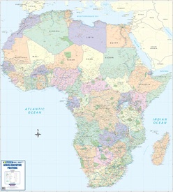
Wandkaart Africa executive Political 2-delig | 176 x 160 cm | MapStudio (9781776170180)

  • ISBN / CODE: 9781776170180
  • Editie: 17-10-2019
  • Druk: 8
  • Aantal blz.: 2
  • Schaal: 1:5000000
  • Uitgever: MapStudio
  • Soort: Wandkaart van continenten
  • Taal: Engels
  • Hoogte: 176.0 cm
  • Breedte: 160.0 cm
  • Gewicht: 678.0 g
  • Bindwijze: -
  • Uitvoering: Papier
  • Schrijf als eerste een review
  • 78,95

    Dit artikel is (tijdelijk) niet leverbaar Dit artikel is (tijdelijk) niet leverbaar

Beschrijving

Africa Executive Political Wall Map is an easy-to-read comprehensive map of Africa includes the new South Sudan boundary.
 
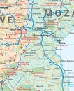
Coverage on the Africa Executive Political Wall Map includes capital cities, major towns, towns, major and main routes with route numbers and distances.
 
Contents of the map of Africa includes national, main and secondary roads in detail, colour-coded countries for convenient overview, rail routes with lines and stations, national parks, reserves, sea routes and distances to major ports, international boundaries, border crossings, airports, airfields, water features (dams, lakes, rivers, deltas), places of interest and historic sites. Coverage shows all countries in Africa including Madagascar.
 

Reviews

Geen reviews gevonden voor dit product.

Schrijf een review

Graag horen wij wat u van dit artikel vindt. Vindt u het goed, leuk, mooi, slecht, lelijk, onbruikbaar of erg handig: schrijf gerust alles op! Het is niet alleen leuk om te doen maar u informeert andere klanten er ook nog mee!