Categorieën
- Nieuwe artikelen
-
Boeken
- Aanwijswoordenboeken
- Accommodatiegidsen
- Atlassen
- Bed and Breakfast Gidsen
- Bergsporthandboeken
- Campergidsen
- Camperhandboeken
- Campinggidsen
- Duikgidsen
- Fietsatlassen
- Fietsgidsen
- Fotoboeken
- Historische Atlassen
- Kanogidsen
- Kinderatlassen
- Kinderreisgidsen
- Kleurboeken
- Klimgids - Klettersteiggidsen
- Klimgids - Klimtopo
- Kookboeken
- Mountainbikegidsen
- Natuurgidsen
- Pelgrimsroutes
- Reisboeken
- Reisdagboeken
- Reisfotografiegidsen
- Reisgidsen
- Reishandboeken
- Reisinspiratieboeken
- Reisverhalen
- Sneeuwschoenwandelgidsen
- Survivalgidsen
- Tourskigidsen
- Treinreisgidsen
- Vaargidsen
- Vogelgidsen
-
Wandelgidsen
- Afrika
- Azië
-
Europa
- Albanië
- Andorra
- Armenië
- België
- Bosnië - Hercegovina
- Bulgarije
- Cyprus
- Denemarken
- Duitsland
-
Engeland
- Noord Engeland
- North East England
- ♦ Northumberland National Park
- Yorkshire and the Humber
- ♦ Yorkshire Dales Nationaal Park
- ♦ North York Moors Nationaal Park
- ■ York
- North West England
- ♦ Cumbria
- ♦ Isle of Man
- ♦ Lake District Nationaal Park
- ♦ North Pennines AONB
- ■ Liverpool
- ■ Manchester
- 🥾 Hadrian's Wall Path
- East Midlands
- West Midlands
- ♦ Peak District Nationaal Park
- ■ Birmingham
- Wales
- Swansea and the Gower
- ♦ Pembrokeshire Coast National Park
- ♦ Snowdonia Nationaal Park
- ♦ Brecon Beacons Nationaal Park
- East of England - East Anglia
- ♦ The Broads National Park
- South West England
- Cornwall
- Devon
- Dorset
- ■ Bath
- ♦ Cotswolds AONB
- ♦ Devon - Cornwall
- 🥾 South West Coast Path
- ♦ New Forrest National Park
- ♦ Exmoor National Park
- ♦ Dartmoor National Park
- ■ Bristol
- South East England
- ♦ Kent
- ♦ South Downs Nationaal Park
- ♦ Isle of Wight
- ■ Londen
- ■ Oxford
- Kanaaleilanden
- ♦ Guernsey
- ♦ Jersey
- Meer steden
- Estland
- Faroer
- Finland
- Frankrijk
- Georgië
- Griekenland
- Groenland
- Hongarije
- IJsland
- Ierland
- Italië
- Kosovo
- Kroatië
- Letland
- Liechtenstein
- Litouwen
- Luxemburg
- Malta
- Montenegro
- Nederland
- Noord-Ierland
- Noord-Macedonië
- Noorwegen
- Oostenrijk
- Polen
- Portugal
- Roemenië
- Scandinavië
- Schotland
- Servië
- Slovenië
- Slowakije
- Spanje
- Tsjechië
- Turkije
- Zweden
- Zwitserland
- Midden-Amerika
- Midden-Oosten
- Noord-Amerika
- Oceanië
- Wereld
- Zuid-Amerika
- Watersport handboeken
- Werken en wonen in buitenland
- Woordenboeken & Taalgidsen
- Kaarten
- Opruiming
- Puzzels
- Travel Gadgets
- Wandkaarten
- Wereldbollen
Veilig online betalen
Betaal veilig via uw eigen bankomgeving
- U bent hier:
- Home
- Europa
- Engeland
- West Midlands
- Boeken
- Wandelgidsen
Geen items in winkelwagen
Ga naar winkelwagen
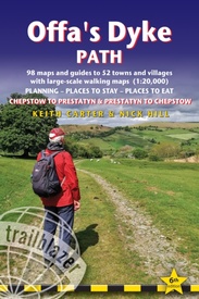
Wandelgids Offa's Dyke Path | Trailblazer Guides (9781912716425)
Chepstow to Prestatyn & Prestatyn to Chepstow
- ISBN / CODE: 9781912716425
- Editie: 2024
- Aantal blz.: 256
- Uitgever: Trailblazer Guides
- Soort: Wandelgids
- Taal: Engels
- Uitvoering: -
- Bindwijze: Paperback
- Schrijf als eerste een review
-
€ 21,95
Dit artikel is (tijdelijk) niet leverbaar Dit artikel is (tijdelijk) niet leverbaar
- Afbeeldingen
- Extra Info
- Inkijkexemplaar
PDF wordt ingeladen...
Beschrijving
Goede wandelgids van de Offa's Dyke Path. Met veel details zijn alle etappes beschreven. Tevens informatie over overnachtingen en openbaar vervoer.
All the information you need to walk Offa's Dyke Path in this two-way edition, with routes re-walked in both directions - from Chepstow to Prestatyn and from Prestatyn to Chepstow and reformatted for use by walkers hiking south to north and north to south. The Offa's Dyke Path is a magnificent National Trail that runs from the North Wales coast to the Severn Estuary following the line of Offa's Dyke, an impressive 8th century earthwork along the English/Welsh border. The ever-changing landscape - the Wye Valley, the Black Mountains, the Shropshire Hills and the Clwydian Hills - is steeped in history and legend providing 177 miles of fascinating walking.
This sixth edition has been re-walked and fully updated and includes:98 walking maps - 1:20,000 (3 and 1/8 inches to 1 mile) - the largest-scale maps availableUnique mapping features - walking times, directions, tricky junctions, places to stay, places to eat, points of interestItineraries for all walkers - whether walking the route in its entirety or sampling the highlights on day walks and short breaksPractical information for all budgets - what to see, where to stay, where to eat: pubs, B&Bs, hotels, campsites, hostels, with reviewsGuides to 52 towns and villages - along the wayPublic transport information - for all access points on the pathGPS waypoints - also downloadable from the Trailblazer website Includes extra colour sections: 16pp colour introduction and 16pp of colour mapping for stage sections (one stage per page) with trail profiles
Reviews
Geen reviews gevonden voor dit product.
Schrijf een review
Graag horen wij wat u van dit artikel vindt. Vindt u het goed, leuk, mooi, slecht, lelijk, onbruikbaar of erg handig: schrijf gerust alles op! Het is niet alleen leuk om te doen maar u informeert andere klanten er ook nog mee!
Alle gerelateerde rubrieken >
Ook interessant voor europa/engeland/west-midlands
-

Wandelkaart - Topografische kaart 15
€ 19,50Topografische kaarten West Midlands -

Wegenkaart - landkaart 6 OS Road Map
€ 12,95Wegenkaarten West Midlands -

Wandelkaart - Topografische kaart 19
€ 19,50Topografische kaarten West Midlands -

Wandelgids 15 Short Walks Malvern Hi
€ 13,95Wandelgidsen West Midlands -

Reisgids 111 places in Places in Cov
€ 19,50Reisgidsen West Midlands


