Mandje Tel: +31503126950 Menu
Winkelwagen
Geen items in winkelwagen
Ga naar winkelwagen

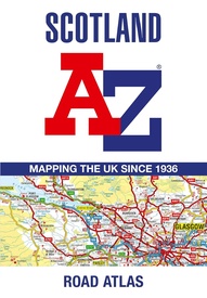
Wegenatlas Scotland - Schotland | A-Z Map Company (9780008652845)

  • ISBN / CODE: 9780008652845
  • Editie: 2024
  • Druk: 4
  • Aantal blz.: 120
  • Schaal: 1:221760
  • Uitgever: A-Z Map Company
  • Soort: Wegenatlas
  • Serie: Regional Road Atlas
  • Taal: Engels
  • Hoogte: 24.5 cm
  • Breedte: 17.5 cm
  • Dikte: 0.5 cm
  • Gewicht: 232.0 g
  • Uitvoering: -
  • Bindwijze: Paperback
  • Beoordeling: 4,2 ★★★★★ (4 reviews) Schrijf een review
  • 13,50

    Levertijd 2 - 4 werkdagen in huis in Belgie Levertijd Nederland Levertijd 2 - 4 werkdagen in huis in Nederland Levertijd Belgie

    Gratis verzending in Nederland vanaf €35,-

Beschrijving

Handzame gedetailleerde wegenatlas van Schotland.

Navigate your way around Scotland with this detailed, full-colour and easy-to-use A-Z Road Atlas.
From the border to the north coast, the mainland pages scale is 3.5 miles to 1 inch and the Western Isles, Shetland Islands and Orkney Islands scale is 4.5 miles to 1 inch.
 
Covering the entire country, this road atlas includes the following features:
• Motorways with full junction detail, primary routes and destinations, A & B roads, under construction and proposed roads, service areas, tolls, mileages, national, county and unitary authority boundaries
• Cairngorms and Loch Lomond & The Trossachs National Park boundaries
• Selected places of interest and tourist information centres
 
20 city and town street maps are included for Aberdeen, Aviemore, Ayr, Dumfries, Dundee, Dunfermline, Edinburgh, Glasgow, Falkirk, Fort William, Hamilton, Inverness, Kilmarnock, Kirkcaldy, Motherwell, Oban, Paisley, Perth, St Andrews and Stirling. Also included is a comprehensive index to cities, towns, villages, hamlets and locations.
Also included are 20 city and town plans for:
 
Aberdeen
Aviemore
Ayr
Dumfries
Dundee
Dunfermline
Edinburgh
Glasgow
Falkirk
Fort William
Hamilton
Inverness
Kilmarnock
Kirkcaldy
Motherwell
Oban
Paisley
Perth
St Andrews
Stirling
 
There is a comprehensive index to cities, towns, villages, hamlets and locations.

Reviews

Formaat te klein maar wel recent

Nadelen: Onhandige wegenatlas. Is een boekje op A5 formaat. Daardoor mis je een totaaloverzicht waardoor een langere route lastig te plannen is. Voordelen: recente wegenatlas (2018) met heel veel informatie.

★★★★★ door Eddy 30 mei 2018

Vond u dit een nuttige review? (login om te beoordelen)

-
Nee (0)
Toppie atlas!!!

Toppie atlas!!!

★★★★★ door Gert van Engelenburg 14 mei 2018

Vond u dit een nuttige review? (login om te beoordelen)

-
Nee (0)
Wegenkaart Schotland

Helemaal top.

★★★★★ door Annelies Weizenbach 13 maart 2018

Vond u dit een nuttige review? (login om te beoordelen)

-
Nee (0)
Toon meer reviews

Schrijf een review

Graag horen wij wat u van dit artikel vindt. Vindt u het goed, leuk, mooi, slecht, lelijk, onbruikbaar of erg handig: schrijf gerust alles op! Het is niet alleen leuk om te doen maar u informeert andere klanten er ook nog mee!