Categorieën
- Nieuwe artikelen
- Boeken
-
Kaarten
- Camperkaarten
- Educatieve kaarten
- Fietskaarten
- Fietsknooppuntenkaarten
- Historische Kaarten
- Pelgrimsroutes (kaarten)
- Spoorwegenkaarten
- Stadsplattegronden
- Toerskikaarten
- Topografische kaarten
- Wandelatlassen
- Wandelkaarten
- Wandelknooppuntenkaarten
- Waterkaarten
- Wegenatlassen
-
Wegenkaarten
- Afrika
- Azië
-
Europa
- Albanië
- Andorra
- Armenië
- Azerbeidzjan
- Belarus - Witrusland
- België
- Bosnië - Hercegovina
- Bulgarije
- Cyprus
- Denemarken
- Duitsland
- Engeland
- Estland
- Faroer
- Finland
- Frankrijk
- Georgië
- Griekenland
- Groenland
- Hongarije
- IJsland
- Ierland
- Italië
- Kosovo
- Kroatië
- Letland
- Liechtenstein
- Litouwen
- Luxemburg
- Malta
- Moldavië
- Monaco
- Montenegro
- Nederland
- Noord-Ierland
- Noord-Macedonië
- Noorwegen
- Oekraïne
- Oostenrijk
- Polen
- Portugal
- Roemenië
- Rusland
- Scandinavië
-
Schotland
- Schotse Hooglanden & Speyside
- ♦ North Coast 500 | NC500
- ♦ Cairngorms National Park
- ♦ Loch Lomond & Trossach National Park
- Orkney Eilanden
- Shetlands | Shetlandeilanden
- Hebriden
- Westelijke Eilanden, Buiten-Hebriden
- Ben Nevis - Glen Coe - Fort William
- Binnen-Hebriden
- Isle of Skye
- Lowlands | Schotse Laaglanden en grenzen
- ♦ Galloway Forest Park
- Edinburgh
- Servië
- Slovenië
- Slowakije
- Spanje
- Tsjechië
- Turkije
- Vaticaanstad
- Zweden
- Zwitserland
- Midden-Amerika
- Midden-Oosten
- Noord-Amerika
- Oceanië
- Wereld
- Zuid-Amerika
- Wintersportkaarten
- Opruiming
- Puzzels
- Travel Gadgets
- Wandkaarten
- Wereldbollen
Veilig online betalen
Betaal veilig via uw eigen bankomgeving
- U bent hier:
- Home
- Europa
- Schotland
- Orkney Eilanden
- Kaarten
- Wegenkaarten
Geen items in winkelwagen
Ga naar winkelwagen
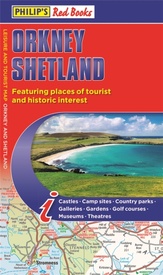
Wegenkaart - landkaart Orkney Shetland | Philip's Maps (9781849075138)
- ISBN / CODE: 9781849075138
- Editie: 2019
- Schaal: 1:160000
- Uitgever: Philip's Maps
- Soort: Wegenkaart
- Taal: Engels
- Hoogte: 23.6 cm
- Breedte: 12.6 cm
- Dikte: 1.4 cm
- Bindwijze: -
- Uitvoering: Papier
- Schrijf als eerste een review
-
€ 11,50
Dit artikel is (tijdelijk) niet leverbaar Dit artikel is (tijdelijk) niet leverbaar
- Afbeeldingen
- Inkijkexemplaar
Beschrijving
Whether it's the outstanding natural beauty, ancient sites or an activity-packed break calling you, the Philip's leisure and tourist map of Orkney and Shetland is all you need. Places of interest are clearly marked on the easy-to-read mapping - ideal for planning that all-important route.
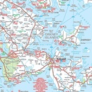
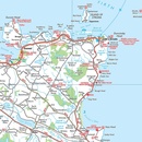
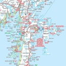
This double-sided Philip's leisure and tourist map of Orkney and Shetland gives detailed coverage of the islands' road networks at an easy-to-read scale of approximately 2.5 miles to 1 inch. The Orkney Islands are featured on side one of the map, with the Shetland Islands shown on the reverse.
The maps show places of tourist and historic interest, including beaches, castles, camping sites, distilleries, galleries, gardens, golf courses, museums, nature trails, historic sites, sports and entertainment venues. From the ancient settlement of Orkney's Skara Brae and Scapa Flow to the Shetland Museum and Bobby's Bus Shelter, all the top places of interest are featured on each side of the map for Orkney and Shetland respectively.
Easily folded (and unfolded), this double-sided sheet map is ideally suited for both leisure and business use, whether by locals or visitors to the islands.
Reviews
Geen reviews gevonden voor dit product.
Schrijf een review
Graag horen wij wat u van dit artikel vindt. Vindt u het goed, leuk, mooi, slecht, lelijk, onbruikbaar of erg handig: schrijf gerust alles op! Het is niet alleen leuk om te doen maar u informeert andere klanten er ook nog mee!
Alle gerelateerde rubrieken >
Ook interessant voor europa/schotland/orkney-eilanden
-

Wandelgids Walks Orkney | Hallewell
€ 5,95Wandelgidsen Orkney Eilanden -

Wandelkaart - Topografische kaart 00
€ 19,50Topografische kaarten Orkney Eilanden -

Reisverhaal Orkney - Shetland | Tini
€ 21,95Reisverhalen Orkney Eilanden -

Wegenkaart - landkaart Orkney Shetla
€ 11,50Wegenkaarten Orkney Eilanden -

Reisgids Travel guides Orkney | Brad
€ 23,95Reisgidsen Orkney Eilanden


