Categorieën
- Nieuwe artikelen
-
Boeken
- Aanwijswoordenboeken
- Accommodatiegidsen
- Atlassen
- Bed and Breakfast Gidsen
- Bergsporthandboeken
- Campergidsen
- Camperhandboeken
- Campinggidsen
- Duikgidsen
- Fietsatlassen
- Fietsgidsen
- Fotoboeken
- Historische Atlassen
- Kanogidsen
- Kinderatlassen
- Kinderreisgidsen
- Kleurboeken
- Klimgids - Klettersteiggidsen
- Klimgids - Klimtopo
- Kookboeken
- Mountainbikegidsen
- Natuurgidsen
- Pelgrimsroutes
- Reisboeken
- Reisdagboeken
- Reisfotografiegidsen
- Reisgidsen
- Reishandboeken
- Reisinspiratieboeken
- Reisverhalen
- Sneeuwschoenwandelgidsen
- Survivalgidsen
- Tourskigidsen
- Treinreisgidsen
- Vaargidsen
- Vogelgidsen
-
Wandelgidsen
- Afrika
- Azië
-
Europa
- Albanië
- Andorra
- Armenië
- België
- Bosnië - Hercegovina
- Bulgarije
- Cyprus
- Denemarken
- Duitsland
- Engeland
- Estland
- Faroer
- Finland
- Frankrijk
- Georgië
- Griekenland
- Groenland
- Hongarije
- IJsland
- Ierland
- Italië
- Kosovo
- Kroatië
- Letland
- Liechtenstein
- Litouwen
- Luxemburg
- Malta
- Montenegro
- Nederland
- Noord-Ierland
- Noord-Macedonië
- Noorwegen
- Oostenrijk
- Polen
- Portugal
- Roemenië
- Scandinavië
-
Schotland
- Schotse Hooglanden & Speyside
- ♦ North Coast 500 | NC500
- ♦ Cairngorms National Park
- ♦ Loch Lomond & Trossach National Park
- Orkney Eilanden
- Shetlands | Shetlandeilanden
- Hebriden
- Ben Nevis - Glen Coe - Fort William
- Binnen-Hebriden
- Isle of Skye
- Arran
- Loch Ness en de Great Glen
- Lowlands | Schotse Laaglanden en grenzen
- ♦ Galloway Forest Park
- Aberdeen
- Edinburgh
- Glasgow
- 🥾 West Highland Way
- Servië
- Slovenië
- Slowakije
- Spanje
- Tsjechië
- Turkije
- Zweden
- Zwitserland
- Midden-Amerika
- Midden-Oosten
- Noord-Amerika
- Oceanië
- Wereld
- Zuid-Amerika
- Watersport handboeken
- Werken en wonen in buitenland
- Woordenboeken & Taalgidsen
- Kaarten
- Opruiming
- Puzzels
- Travel Gadgets
- Wandkaarten
- Wereldbollen
Veilig online betalen
Betaal veilig via uw eigen bankomgeving
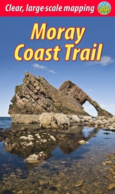
Wandelgids Moray Coast Trail | Rucksack Readers (9781898481980)
with Dava Way and Moray Way
- ISBN / CODE: 9781898481980
- Editie: 04-03-2021
- Druk: 2
- Aantal blz.: 72
- Schaal: 1:40000
- Auteur(s): Sandra Bardwell
- Uitgever: Rucksack Readers
- Soort: Wandelgids
- Taal: Engels
- Hoogte: 22.0 cm
- Breedte: 13.0 cm
- Dikte: 0.8 cm
- Gewicht: 161.0 g
- Uitvoering: Scheur- en watervast
- Bindwijze: Paperback
- Schrijf als eerste een review
-
€ 19,95
Leverbaar in 3 - 5 werkdagen in huis in Belgie Levertijd Nederland Leverbaar in 3 - 5 werkdagen in huis in Nederland Levertijd Belgie
Gratis verzending in Nederland vanaf €35,-
- Extra Info
- Inkijkexemplaar
Beschrijving
- detailed description of the route from west to east
- summary of each section with terrain, grade and refreshments
- map of the entire route in 6 drop-down panels (1:110,000)
- section about the tragic life of Mary Queen of Scots
- practical information about public transport and travel
- lavishly illustrated, with over 80 colour photographs
- rucksack-friendly and printed on rainproof paper.
Reviews
Geen reviews gevonden voor dit product.
Schrijf een review
Graag horen wij wat u van dit artikel vindt. Vindt u het goed, leuk, mooi, slecht, lelijk, onbruikbaar of erg handig: schrijf gerust alles op! Het is niet alleen leuk om te doen maar u informeert andere klanten er ook nog mee!
Ook interessant voor europa/schotland/overig-zuid
-

Wandelgids Southern Uplands | Pocket
€ 10,95Wandelgidsen Lowlands | Schotse Laaglanden en grenzen -

Wandelkaart - Topografische kaart 35
€ 19,50Topografische kaarten Lowlands | Schotse Laaglanden en grenzen -

Wandelkaart - Topografische kaart 32
€ 19,50Topografische kaarten Lowlands | Schotse Laaglanden en grenzen -

Wandelkaart - Topografische kaart 32
€ 19,50Topografische kaarten Lowlands | Schotse Laaglanden en grenzen -

Wandelkaart - Topografische kaart 07
€ 19,50Topografische kaarten Lowlands | Schotse Laaglanden en grenzen


