Categorieën
- Nieuwe artikelen
- Boeken
-
Kaarten
- Camperkaarten
- Educatieve kaarten
- Fietskaarten
- Fietsknooppuntenkaarten
- Historische Kaarten
- Pelgrimsroutes (kaarten)
- Spoorwegenkaarten
- Stadsplattegronden
- Toerskikaarten
- Topografische kaarten
- Wandelatlassen
- Wandelkaarten
- Wandelknooppuntenkaarten
- Waterkaarten
- Wegenatlassen
-
Wegenkaarten
- Afrika
- Azië
-
Europa
- Albanië
- Andorra
- Armenië
- Azerbeidzjan
- Belarus - Witrusland
- België
- Bosnië - Hercegovina
- Bulgarije
- Cyprus
- Denemarken
- Duitsland
- Engeland
- Estland
- Faroer
- Finland
- Frankrijk
- Georgië
- Griekenland
- Groenland
- Hongarije
- IJsland
- Ierland
- Italië
- Kosovo
- Kroatië
- Letland
- Liechtenstein
- Litouwen
- Luxemburg
- Malta
- Moldavië
- Monaco
- Montenegro
- Nederland
- Noord-Ierland
- Noord-Macedonië
- Noorwegen
- Oekraïne
- Oostenrijk
- Polen
- Portugal
- Roemenië
- Rusland
- Scandinavië
- Schotland
- Servië
- Slovenië
- Slowakije
-
Spanje
- Noordwest Spanje - Galicië - Asturië
- Galicië
- Asturië
- Cantabrië
- ♦ Picos de Europa
- Castilië en León
- Baskenland
- Navarra
- La Rioja
- 🥾 Wandelroute Santiago de Compostela
- Aragon
- Catalonië
- ■ Barcelona
- ♦ Costa Brava
- Spaanse Pyreneeën
- Madrid (provincie)
- Madrid
- Extremadura
- Castilla-La Mancha
- Centraal Spanje
- Spanje oost - Costa Blanca
- Valencia (autonome regio)
- ♦ Costa Blanca
- Murcia (autonome regio)
- Andalusië - Zuid Spanje
- ♦ Costa del Sol
- Balearen
- Mallorca
- Menorca
- Ibiza
- Canarische Eilanden
- Tenerife
- Gran Canaria
- La Gomera
- La Palma
- El Hierro
- Lanzarote
- Fuerteventura
- Gibraltar
- Tsjechië
- Turkije
- Vaticaanstad
- Zweden
- Zwitserland
- Midden-Amerika
- Midden-Oosten
- Noord-Amerika
- Oceanië
- Wereld
- Zuid-Amerika
- Wintersportkaarten
- Opruiming
- Puzzels
- Travel Gadgets
- Wandkaarten
- Wereldbollen
Veilig online betalen
Betaal veilig via uw eigen bankomgeving
- U bent hier:
- Home
- Europa
- Spanje
- Noordwest Spanje - Galicië - Asturië
- Kaarten
- Wegenkaarten
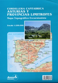
Wegenkaart - landkaart Cordillera Cantabrica – Asturias y provincias limitrofes | Adrados Ediciones (9788494080739)
- ISBN / CODE: 9788494080739
- Schaal: 1:200000
- Uitgever: Adrados Ediciones
- Soort: Wegenkaart
- Taal: Spaans
- Schrijf als eerste een review
-
€ 14,95
Op voorraad. Binnen 2 - 3 werkdagen in huis in Belgie Levertijd Nederland Voor 17.00 uur op werkdagen besteld, morgen in huis in Nederland Levertijd Belgie
Gratis verzending in Nederland vanaf €35,-
- Afbeeldingen
- Inkijkexemplaar
Beschrijving
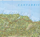
Gedetailleerde wegenkaart an de Cordillera Cantabrica met hoogtelijnen, hoogte verschillen in kleur en schaduw en UTM coördinaten. Met plaatsnamen index!
Cordillera Cantabrica on a detailed road map from the Oviedo based Adrados Ediciones, presenting this mountainous region with contours at 100m intervals, altitude coluring, relief shading and UTM coordinates.
Since the publishers specialize in detailed hiking maps, including the best coverage of the Picos de Europa, the map includes an exceptionally large number of names of peaks, passes, etc. Symbols highlight best rock and ice climbing areas, huts and refuges, campsites, mountain rescue posts and information centres. Along the coast numerous beaches are named.
Road network includes small country roads and tracks. Local railway lines are shown, although not very easy to see on the base map filled with so much information. The map has a 10km UTM grid. Map legend is in Spanish only.
On the reverse is a panorama drawing of the area, looking south from the coast with León and Pontevedra in the background. Numerous towns and villages, as well as peaks of the Cordillera Cantabrica are named. An administrative map of the area shows its division into communes and highlights its many protected areas, accompanied by an index listing, where appropriate, each commune with its highest peak.
Also included is a very extensive list of all the peaks in the Cordillera Cantabrica over 1200m. Accompanying notes are in Spanish only.
Important - please note: All place names are in the local dialect, so Xixon for Gijón, Uvieu for Oviedo, etc. The map is printed on glossy paper and may not withstand repeated folding and unfolding whilst traveling by car, but it is ideal for finding out more about this fascinating region outside its main attraction, the Picos de Europa.
Reviews
Geen reviews gevonden voor dit product.
Schrijf een review
Graag horen wij wat u van dit artikel vindt. Vindt u het goed, leuk, mooi, slecht, lelijk, onbruikbaar of erg handig: schrijf gerust alles op! Het is niet alleen leuk om te doen maar u informeert andere klanten er ook nog mee!
Ook interessant voor europa/spanje/noordwestspanje
-

Wandelkaart Parque Natural de Somied
€ 14,95Wandelkaarten Noordwest Spanje - Galicië - Asturië -

Reisgids Dominicus Noord Spanje | Go
€ 23,99Reisgidsen Noordwest Spanje - Galicië - Asturië -

Fietsgids Fiets, vecht, huil, bid, l
€ 29,95Fietsgidsen Noordwest Spanje - Galicië - Asturië -

Wegenkaart - landkaart 141 Galicië -
€ 10,95Wegenkaarten Noordwest Spanje - Galicië - Asturië -

Wandelgids Camino del Norte | Uitgev
€ 19,99Wandelgidsen Noordwest Spanje - Galicië - Asturië


