
Wandkaarten
Wandkaart kopen? Van landkaarten tot kinderwereldkaarten en prikborden, wij hebben een uitgebreide collectie in onze webshop
Verfraai uw interieur met een wandkaart aan de muur, bijvoorbeeld van uw favoriete vakantiebestemming, of van die bijzondere plaats waar u nog weleens naar terug wilt. Kies bijvoorbeeld voor een landkaart of een wereldkaart. Of voor een handig prikbord of educatieve, speelse kinderwereldkaart.
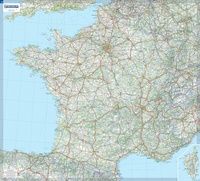 Wandkaart Frankrijk – France, 111 x 100 cm | Michelin
Dubbelzijdig geplastificeerde wandkaart van de klassieke overzichtskaart van Michelin Frankrijk. Als altijd zeer overzichtelijk en voorzien van een mooie heldere kleurstelling. Prachtig aan de muur! Op deze kaart is het wegennet identiek …
★★★★★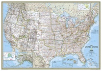 Wandkaart 02008 USA - Verenigde Staten Political, 178 x 124 cm | National Geographic
Het klassieke kaartbeeld van National Geographic, de grenzen van de staten van Amerika zijn apart gekleurd. De wandkaart is heel gedetailleerd met veel plaatsen, wegen, rivieren en nationale parken, het …
★★★★★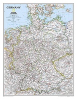 Wandkaart 02814 Germany – Duitsland, 58 x 76 cm | National Geographic
Decoratieve wandkaart van Duitsland. Naast de mooie kleuren staan er bijzonder veel plaatsen op vermeld. National Geographic's political map of Germany includes everything from country boundaries, major roads, towns …
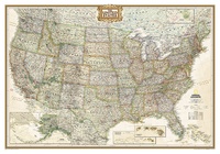 Wandkaart 20114 USA - Verenigde Staten politiek, antiek, 108 x 75 cm | National Geographic
Wandkaart van de USA waarbij de kleuren in 'antieke' look zijn weergegeven, de staatgrenzen zeer duidelijk zijn en er veel plaatsen op staan. This Antique-style USA Wall Map by National …
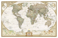
★★★★★★★★★★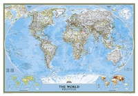 Wereldkaart 22005 Politiek, 110 x 77 cm | National Geographic
Politieke wereldkaart van National Geographic. De klassieke blauwe vorm, met helder kaartbeeld. De landen hebben met kleuren duidelijke grenzen en er staan opvallend veel topografische details op. Ondanks de schaal …
★★★★★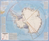 Wandkaart Antarctica – Zuidpool, 120 x 100 cm | Maps International
Fraaie kaart van het continent waarbij zowel de natuurkundige als de politieke aspecten zichtbaar zijn. Alle bezettingsstations, berggebieden en landingsplaatsen staan er op. Maps International's collection of continental maps would …
★★★★★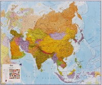 Wandkaart Azië Politiek, 120 x 100 cm | Maps International
Fraaie politieke kaart van het continent, waarbij vooral de politieke aspecten heel duidelijk te lezen zijn. Alle landen hebben verschillende kleuren, steden en belangrijke verbindingen zijn goed te vinden. Papieren …
★★★★★★★★★★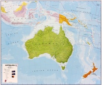 Wandkaart Australasia - Australië, Nieuw Zeeland en deel Oceanië, 120 x 100 cm | Maps International
Fraaie politieke kaart van het continent, waarbij vooral de politieke aspecten heel duidelijk te lezen zijn. Alle landen hebben verschillende kleuren, steden en belangrijke verbindingen zijn goed te vinden. Maps …
★★★★★★★★★★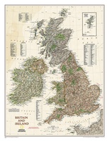 Wandkaart 20442 Groot Brittannië en Ierland antiek, 60 x 76 cm | National Geographic
This map of Britain and Ireland shows country boundaries, thousands of place names, major roadways, airports, bodies of water, and more. Rich earth-toned colors, astounding detail and boardroom quality make …
★★★★★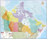 Wandkaart Canada, 120 x 100 cm | Maps International
Mooi, heldere wandkaart van Canada. This Canada wall map clearly depicts all the cities, major roads and also shows all the Provinces and Territory boundaries. All major cities and …
★★★★★★★★★★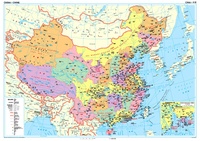 Wandkaart China – political, 95 x 69 cm | Gizi Map
Een wandkaart van China waarop de politieke grenzen en steden tweetalig staan weergeven. Natuurkundige aspecten zijn weggelaten, maar dat komt de politieke en bestuurlijke indeling duidelijk ten goede. Afmetingen: 69cm.x …
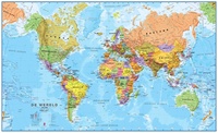
 Wereldkaart 62P-mvl Politiek, 68 x 53 cm | Maps International
Door het heldere en vrij felle kleurgebruik is deze kaart uitermate geschikt voor scholen, kantoren of gewoon als politieke wereldkaart thuis. Bedenk wel dat deze maat klein is om van …
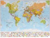
 Wereldkaart 22085 Politiek & antiek, 117 x 76 cm | National Geographic
Een prachtige, stijlvol gekleurde kaart - bruin, antieke uitstraling - met een modern kaartbeeld. Alle landen staan er met grenzen en belangrijke steden keurig op, maar de nadruk ligt op …
★★★★★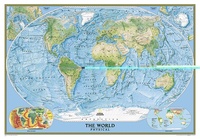 Wereldkaart 22090 Natuurkundig - the world physical, 178 x 122 cm | National Geographic
Bijzonder fraaie natuurkundige kaart van National Geographic waarbij het accent ligt op de fysische aspecten van de aarde met veel details van de oceanen. Een schoonheid aan de muur! Our …
★★★★★ Wereldkaart 62P-zvl Politiek, 68 x 45 cm | Maps International
Door het heldere en vrij felle kleurgebruik is deze kaart uitermate geschikt voor scholen, kantoren of gewoon als politieke wereldkaart thuis. Bedenk wel dat deze maat klein is om van …
★★★★★ Wereldkaart 66P-zvl Politiek, 136 x 86 cm | Maps International
Prachtige geplastificeerde wereldkaart. Door het heldere en vrij felle kleurgebruik is deze kaart uitermate geschikt voor scholen, kantoren of gewoon als politieke wereldkaart thuis. De kleurstellig is zodanig dat elk …
★★★★★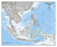 Wandkaart 20620 Zuidoost Azië, politiek, 96 x 81 cm | National Geographic
The Southeast Asia Political Map is a detailed reference map containing National Geographic’s clear visual presentation in a bright and appealing color palette. The map contains thousand of place names, …
★★★★★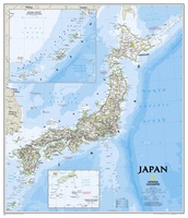 Wandkaart Japan, 63 x 74 cm | National Geographic
This classic-style map of Japan shows political boundaries, major highways and roads, cities and towns, airports, and other geographic details. Thousands of place-names and exact borders are carefully researched by …
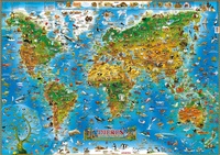 Kinderwereldkaart 92 Dieren van de wereld, 140 x 100 cm | Dino's Maps
DINO'S Geïllustreerde Kaart van de wereld van de Dieren is een aantrekkelijke en kleurrijke presentatie van de dieren, verspreid over de hele wereld, in hun natuurlijke geografische en biologische omgeving. …
★★★★★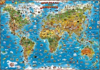 Kinderwereldkaart 93 Wereldkaart voor kinderen, 140 x 100 cm | Dino's Maps
De kaart laat de geografische, etnografische (folklore, geschiedenis, cultuur), gastronomische, biologische (dieren, het leven in de zee, flora) en andere algemene wetenswaardigheden (betreffende sport, luchtvaart, schepen en vaartuigen) van de …
★★★★★
Laatste reviews

Super handig fiets boekje en mooi water bestendig. En handig om op de kaarten te kijken heel duidelijk beschrijving. Wij fietsen al jaren in Duitsland …
★★★★★ door Jenneke holterman 19 november 2024 | Heeft dit artikel gekocht
prima kaart levering en betaling allemaal vlot verlopen
★★★★★ door Marc Buts 19 november 2024 | Heeft dit artikel gekocht
Ik heb een uitklapbare kaart van Londen gekocht voor toeristische doeleinden. Snel geleverd en een product die volledig voldoet aan de behoeften. Chapeau!
★★★★★ door Cees Lindenberg 18 november 2024 | Heeft dit artikel gekocht
Mooi stevig, klein koffertje. Ik had eerst de 'middenmaat' besteld maar die was helaas niet meer leverbaar. Snelle en goede communicatie hierover. Het kleinste formaat …
★★★★★ door Marieke 17 november 2024 | Heeft dit artikel gekocht