
Wandkaarten van continenten
Continentkaart kopen? Hang de wereld aan de muur met onze collectie continentwandkaarten
Met een continentkaart heeft u bijvoorbeeld een kaart van Afrika, van Europa of van Azië in uw huis hangen. De meeste van deze kaarten zijn zeer gedetailleerd, zo kunt u deze landen verkennen op uw muur, een reis plannen of een eerdere reis juist herinneren.
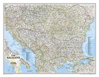 Wandkaart 20581 The Balkans - Balkan landen, 77 x 60 cm | National Geographic
Study the countries of the Balkans with our new map featuring the classic National Geographic reference styling. Features thousands of place names, accurate political boundaries, national parks, and major infrastructure …
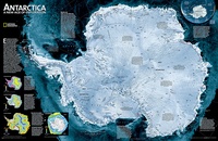 Wandkaart 20091 Antarctica Satellite Map, 78 x 50 cm | National Geographic
This digital mosaic of 4,500 satellite scans shows incredible detail of Antarctica's terrain. Includes insets that show the surface elevation, ice sheet thickness, ice flow velocity, and sea ice movement …
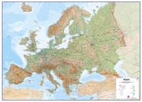 Wandkaart Europa Natuurkundig, 135 x 98 cm | Maps International
Maps International's large physical wall map of Europe is one of the finest money can buy. European Map details: Our large physical wall map of Europe features the natural …
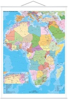 Wandkaart Africa – Afrika, 97 x 119 cm | Stiefel
Duidelijke, heldere kaart van Afrika. Geplastificeerd met metalen ophangstrips.Beschrijfbaar en afwisbaar. Wandkarte mit Metallbeleistung - beschreib- und abwischbar - extrem reißfest- - Ländergrenzen - alle wichtigen Städte und Hauptstädte - …
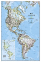 Wandkaart 02809 The Americas - Noord & Zuid Amerika, politiek, 60 x 94 cm | National Geographic
National Geographic's Classic style political wall map of The Americas features a bright color palette with blue oceans and the continents' terrain detailed in stunning shaded relief that has been …
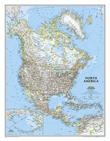 Wandkaart 20014 Noord Amerika, politiek, 60 x 77 cm | National Geographic
The political map of North America features trademark National Geographic detail and accuracy. The map shows country boundaries, place names, major highways and roads, bodies of water, and more. An …
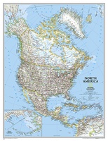 Wandkaart 20035 Noord Amerika, politiek, 91 x 118 cm | National Geographic
The political map of North America features trademark National Geographic detail and accuracy. The map shows country boundaries, place names, major highways and roads, bodies of water, and more. An …
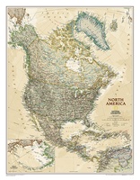 Wandkaart 20462 Noord Amerika, politiek & antiek, 60 x 78 cm | National Geographic
This richly colored map of North America - featuring country boundaries, place names, major highways and roads, and bodies of water - is excellent for reference in your home or …
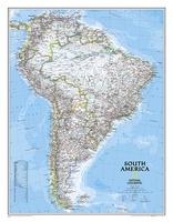 Wandkaart 20069 Zuid Amerika, politiek, 54 x 74 cm | National Geographic
This classic map of South America shows political boundaries, place names, airports, major roads and highways, and other geographic features for the entire continent.
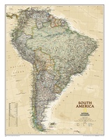 Wandkaart 20448 Zuid Amerika, politiek & antiek, 60 x 77 cm | National Geographic
This elegant, richly colored map of South America shows political boundaries, place names, airports, major roads and highways, and other geographic features for the entire continent.
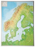 Wandkaart - Reliëfkaart Scandinavië met voelbaar 3D reliëf 77 x 55 x 2 cm | GeoRelief
De uitgever van de kaart is de bekende Duitse uitgever GeoRelief GbR. Deze topografische kaart van Scandinavië heeft een hoge kwaliteit met prachtige kleuren (engelse versie). De kaart bevat de …
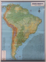 Wandkaart America South Physical Map - Zuid-Amerika | ITMB
Fysieke muurkaart van Zuid-Amerika (in het Engels) met metalen latten om de kaart gemakkelijk op te hangen en vast te houden.
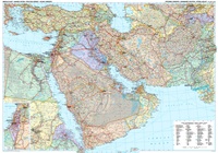 Wandkaart Middle East Political - Midden-Oosten politiek | 125 x 88 cm | Gizi Map
Mooie wandkaart van het Midden-Oosten van Gizi Map met de volgende landen Egypte, Soedan, Saoedi-Arabië, Oman, Jemen, Koeweit, Qatar, Eritrea, Verenigde Arabische Emiraten, Jordanië, Iran, Irak, Syrië, Turkije, Palestijnse Autoriteit, …
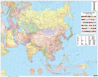 Wandkaart Asia Political & Physical | 154 x 121 cm | Freytag & Berndt
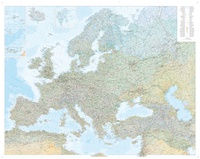 Wandkaart Europa fysisch | 128 x 100 cm | Kümmerly & Frey
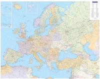 Wandkaart Europe Political | 126 x 100 cm | Kümmerly & Frey
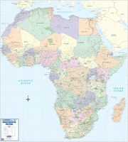 Wandkaart Africa executive Political 2-delig | 176 x 160 cm | MapStudio
Africa Executive Political Wall Map is an easy-to-read comprehensive map of Africa includes the new South Sudan boundary. Coverage on the Africa Executive Political Wall Map includes capital cities, …
Waar moet je op letten als je een goede wandkaart van een continent wilt kopen?
Welke verschillende soorten wandkaarten van werelddelen zijn er eigenlijk:
Van welke continenten zijn er wandkaarten?
Het formaat van een wandkaart van een werelddeel
De leesbaarheid van een wandkaart van een continent
Veel uitvoeringen van dezelfde wandkaart van een wereldeel
Hoe wordt de wandkaart verzonden?
Laatste reviews

Heb de gids cadeau gedaan en die persoon was er heel blij mee ..
★★★★★ door J 21 november 2024 | Heeft dit artikel gekocht
De kaart van Kirgystan is prachtig, zeer gedetailleerd. Kan niet wachten tot de we echt op reis hmgaan die kant op.
★★★★★ door Marijke Eering 21 november 2024 | Heeft dit artikel gekocht
Super handig fiets boekje en mooi water bestendig. En handig om op de kaarten te kijken heel duidelijk beschrijving. Wij fietsen al jaren in Duitsland …
★★★★★ door Jenneke holterman 19 november 2024 | Heeft dit artikel gekocht
prima kaart levering en betaling allemaal vlot verlopen
★★★★★ door Marc Buts 19 november 2024 | Heeft dit artikel gekocht