
Wandelkaart - Topografische kaart 2432ET Massif du Sancy | IGN - Institut Géographique National (9782758551492)
PNR des Volcans d'Auvergne

- ISBN / CODE: 9782758551492
- Editie: nieuwste editie
- Schaal: 1:25000
- Uitgever: IGN - Institut Géographique National
- Soort: Topografische kaart, Wandelkaart
- Serie: Top 25
- Taal: Engels, Frans
- Uitvoering: Papier
- Bindwijze: -
- Beoordeling: 4,2 ★★★★★ (4 reviews) Schrijf een review
-
€ 16,95
Op voorraad. Voor 17.00 uur op werkdagen besteld, morgen in huis in Nederland Levertijd Belgie
Gratis verzending in Nederland vanaf €35,-


-
Topografische kaarten IGN 25.000 Auvergne : Noord
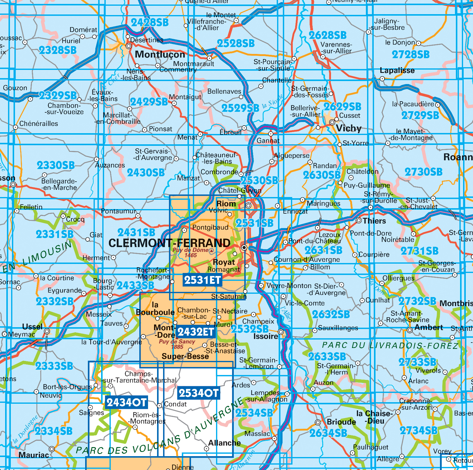
Producten op deze overzichtskaart:
Klik op een product om naar de pagina van dat product te gaan.
- Wandelkaart - Topografische kaart 2327SB Culan - Châteaumeillant | IGN - Institut Géographique National
- Wandelkaart - Topografische kaart 2328SB Huriel - Boussac | IGN - Institut Géographique National
- Wandelkaart - Topografische kaart 2329SB Évaux-les-Bains | IGN - Institut Géographique National
- Wandelkaart - Topografische kaart 2330SB Auzances - Aubusson | IGN - Institut Géographique National
- Wandelkaart - Topografische kaart 2331SB Felletin | IGN - Institut Géographique National
- Wandelkaart - Topografische kaart 2332SB Ussel | IGN - Institut Géographique National
- Wandelkaart - Topografische kaart 2333SB Bort-les-Orgues | IGN - Institut Géographique National
- Wandelkaart - Topografische kaart 2334SB Mauriac | IGN - Institut Géographique National
- Topografische kaart - Wandelkaart 2427SB Cérilly | IGN - Institut Géographique National
- Wandelkaart - Topografische kaart 2428SB Montluçon | IGN - Institut Géographique National
- Wandelkaart - Topografische kaart 2429SB Saint-Éloy-les-Mines | IGN - Institut Géographique National
- Wandelkaart - Topografische kaart 2430SB Saint-Gervais d'Auvergne | IGN - Institut Géographique National
- Wandelkaart - Topografische kaart 2431SB Pontaumur | IGN - Institut Géographique National
- Wandelkaart - Topografische kaart 2432ET Massif du Sancy | IGN - Institut Géographique National
- Topografische kaart - Wandelkaart 2433SB la Bourboule | IGN - Institut Géographique National
- Wandelkaart - Topografische kaart 2434OT Riom es Montagnes, Bort-les-Orgues, PNR des Volcans d'Auvergne | IGN - Institut Géographique National
- Topografische kaart - Wandelkaart 2527SB Bourbon-l'Archambault | IGN - Institut Géographique National
- Wandelkaart - Topografische kaart 2528SB Tronget - Montmarault | IGN - Institut Géographique National
- Wandelkaart - Topografische kaart 2529SB Gannat | IGN - Institut Géographique National
- Wandelkaart - Topografische kaart 2530SB Aigueperse, Châtel-Guyon, Manzat | IGN - Institut Géographique National
- Wandelkaart - Topografische kaart 2531ET Chaîne des Puys | IGN - Institut Géographique National
- Wandelkaart - Topografische kaart 2531SB Clermont-Ferrand | IGN - Institut Géographique National
- Wandelkaart - Topografische kaart 2532SB Veyre-Monton, Issoire | IGN - Institut Géographique National
- Wandelkaart - Topografische kaart 2534OT Monts du Cezallier, Condat, Allanche, Parc Volcans d'Auvergne | IGN - Institut Géographique National
- Wandelkaart - Topografische kaart 2534SB Massiac - Ardes | IGN - Institut Géographique National
- Wandelkaart - Topografische kaart 2631SB Thiers | IGN - Institut Géographique National
- Wandelkaart - Topografische kaart 2632SB Issoire | IGN - Institut Géographique National
- Wandelkaart - Topografische kaart 2633SB St-Germain-l'Herm, Brassac-les-Mines | IGN - Institut Géographique National
- Wandelkaart - Topografische kaart 2634SB Paulhaguet - Brioude | IGN - Institut Géographique National
- Wandelkaart - Topografische kaart 2731SB Noirétable | IGN - Institut Géographique National
- Wandelkaart - Topografische kaart 2732SB Ambert | IGN - Institut Géographique National
- Wandelkaart - Topografische kaart 2734SB Allègre, La Chaise-Dieu, Craponne-sur-Arzon | IGN - Institut Géographique National
-
Wandelkaarten IGN 25.000 Auvergne : Noord


Producten op deze overzichtskaart:
Klik op een product om naar de pagina van dat product te gaan.
- Wandelkaart - Topografische kaart 2327SB Culan - Châteaumeillant | IGN - Institut Géographique National
- Wandelkaart - Topografische kaart 2328SB Huriel - Boussac | IGN - Institut Géographique National
- Wandelkaart - Topografische kaart 2329SB Évaux-les-Bains | IGN - Institut Géographique National
- Wandelkaart - Topografische kaart 2330SB Auzances - Aubusson | IGN - Institut Géographique National
- Wandelkaart - Topografische kaart 2331SB Felletin | IGN - Institut Géographique National
- Wandelkaart - Topografische kaart 2332SB Ussel | IGN - Institut Géographique National
- Wandelkaart - Topografische kaart 2333SB Bort-les-Orgues | IGN - Institut Géographique National
- Wandelkaart - Topografische kaart 2334SB Mauriac | IGN - Institut Géographique National
- Topografische kaart - Wandelkaart 2427SB Cérilly | IGN - Institut Géographique National
- Wandelkaart - Topografische kaart 2428SB Montluçon | IGN - Institut Géographique National
- Wandelkaart - Topografische kaart 2429SB Saint-Éloy-les-Mines | IGN - Institut Géographique National
- Wandelkaart - Topografische kaart 2430SB Saint-Gervais d'Auvergne | IGN - Institut Géographique National
- Wandelkaart - Topografische kaart 2431SB Pontaumur | IGN - Institut Géographique National
- Wandelkaart - Topografische kaart 2432ET Massif du Sancy | IGN - Institut Géographique National
- Topografische kaart - Wandelkaart 2433SB la Bourboule | IGN - Institut Géographique National
- Wandelkaart - Topografische kaart 2434OT Riom es Montagnes, Bort-les-Orgues, PNR des Volcans d'Auvergne | IGN - Institut Géographique National
- Topografische kaart - Wandelkaart 2527SB Bourbon-l'Archambault | IGN - Institut Géographique National
- Wandelkaart - Topografische kaart 2528SB Tronget - Montmarault | IGN - Institut Géographique National
- Wandelkaart - Topografische kaart 2529SB Gannat | IGN - Institut Géographique National
- Wandelkaart - Topografische kaart 2530SB Aigueperse, Châtel-Guyon, Manzat | IGN - Institut Géographique National
- Wandelkaart - Topografische kaart 2531ET Chaîne des Puys | IGN - Institut Géographique National
- Wandelkaart - Topografische kaart 2531SB Clermont-Ferrand | IGN - Institut Géographique National
- Wandelkaart - Topografische kaart 2532SB Veyre-Monton, Issoire | IGN - Institut Géographique National
- Wandelkaart - Topografische kaart 2534OT Monts du Cezallier, Condat, Allanche, Parc Volcans d'Auvergne | IGN - Institut Géographique National
- Wandelkaart - Topografische kaart 2534SB Massiac - Ardes | IGN - Institut Géographique National
- Wandelkaart - Topografische kaart 2631SB Thiers | IGN - Institut Géographique National
- Wandelkaart - Topografische kaart 2632SB Issoire | IGN - Institut Géographique National
- Wandelkaart - Topografische kaart 2633SB St-Germain-l'Herm, Brassac-les-Mines | IGN - Institut Géographique National
- Wandelkaart - Topografische kaart 2634SB Paulhaguet - Brioude | IGN - Institut Géographique National
- Wandelkaart - Topografische kaart 2731SB Noirétable | IGN - Institut Géographique National
- Wandelkaart - Topografische kaart 2732SB Ambert | IGN - Institut Géographique National
- Wandelkaart - Topografische kaart 2734SB Allègre, La Chaise-Dieu, Craponne-sur-Arzon | IGN - Institut Géographique National
Overzichtskaarten
Beschrijving
Reviews
Wandelkaart Auvergne: Het is wat het is, maar de Belgische wandel/stafkaarten zijn beter. Daar staan alle mogelijke paadjes op en dit is niet zo met de Franse wandelkaarten. Maar dit is geen kritiek op jullie, het is nu eenmaal zo. En betere zijn er niet te krijgen. Bezorging was optimaal!
★★★★★ door Agnes Lammens 1 oktober 2020Vond u dit een nuttige review? (login om te beoordelen)
De IGN-kaarten zijn altijd van goede kwaliteit en hebben een voldoende zoomniveau om je wandelingen mee te kunnen plannen. Ook deze ziet er erg goed uit. Een absolute must als je in Frankrijk de natuur in wilt!
★★★★★ door Mark 18 april 2017Vond u dit een nuttige review? (login om te beoordelen)
Zeer gedetailleerd en duidelijke kaart, helaas enigszins verouderd. Zo staan niet alle paden op de kaart en enkele paden zijn inmiddels dichtgegroeid.
★★★★★ door Marco van Schaik 13 oktober 2016Vond u dit een nuttige review? (login om te beoordelen)
Schrijf een review
Graag horen wij wat u van dit artikel vindt. Vindt u het goed, leuk, mooi, slecht, lelijk, onbruikbaar of erg handig: schrijf gerust alles op! Het is niet alleen leuk om te doen maar u informeert andere klanten er ook nog mee!
Ook interessant voor europa/frankrijk/auvergne
-

Campergids 11 Mit dem Wohnmobil in d
€ 23,95Campergidsen Auvergne - Cantal -

Reisgids Betoverend Auvergne | Edico
€ 24,50Reisgidsen Auvergne - Cantal -

Wandelgids P431 Le Velay... à pied |
€ 14,50Wandelgidsen Auvergne - Cantal -

Wandelkaart - Topografische kaart 27
€ 16,95Topografische kaarten Auvergne - Cantal -

Fietskaart - Wegenkaart - landkaart
€ 10,95Fietskaarten Auvergne - Cantal